
This road, which lies parallel with Main Street, was originally known as Back Way or Back Lane and was just a farm track which was only accessible by farm vehicles.
There were three families recorded as inhabitants of Back Way in the 1841 census; the Landins, Spencers and Herepath. (The 1841 Census of England, Wales, Scotland, Channel Islands and Isle of Man was taken on the night of 6 June, and it was the first census conducted by the General Register Office to record the names of everyone in a household or institution.)
By 1871, we find that there are now five families living on Back Way, with the Landin Family still in occupation, although it is another member as head, as George Landin died in 1861. From its position at the western end of the track we can deduce that this is the cottage we now know as ‘The Yews’.
EAST END TO PLAYING FIELD
It is not until the 1891 census that the house named Cherry Holt appears, and the road is now called ‘Back Lane’. Thomas Mould, who is listed as the ‘head’ of Cherry Holt, and whose occupation is a self-employed gardener.
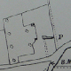
The map on the left is from the 1800’s showing Cherry Holt and an Orchard where Thomas Mould would have run his Market Garden business from.
It wasn’t until the early 1960’s that the building of new homes commenced on the north side of BackLane. Outline planning permission was applied for in July 1960 for properties on land that was under the ownership of Conrad Wells; the Saddler in Main Street, namely plots 18 to 24.
The first plots numbered 18 and 24, were sold for £250, and we can see from the 1965 aerial picture, number 18 was the first home to be built. Although number 24 was the second plot to be sold, due to problems with the original buyer, this development actually ended up being the last one to be completed; Joan and Trevor Danks moved into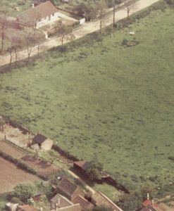 this bungalow in 1967. It was some two years before the final 2 plots were sold.
The next piece of land to be sold on the north side belonged to Jimmy Chambers of Cherry Holt. Outline planning permission for properties number 6 to 16 was applied for in January 1965, and the building of the bungalows followed from 1966 onwards. In such a short space of time the value of land had increased and by the time plot number 16 was purchased the price had quadrupled.
Also shown in the picture is the land which was purchased by New Era Development (Peterborough) Ltd from Phipps Brewery in 1967. For many years, this field had been used as the village playing field. However, it wasn’t until 1972 that the building of the four houses was started, and a new village playing area had to be found.
The little brick building covered in ivy, on the land joining number 11, was the old Slaughter House which was built on the land belonging to the Saddlery.
The renaming of Back Lane was first mentioned in Parish Council minutes in 1963 and on Monday, 6th May at the Annual Parish Meeting a vote for suggested names was taken:
Cherry Tree Lane -2 votes
Cherry Lane – 3 votes
Orchard Lane – 5 votes
These suggestions were sent to the RDC.
The street name plate ‘Orchard Lane’ finally made an appearance in 1975, according to the PC minutes from April 21st of that year. Street lighting was then installed and the 30 mph road sign followed.
2015 & 2019
ALLOTMENTS OFF ORCHARD LANE
In 1919 the ownership of a field known as Sand Holes, located to the north of Orchard Lane (then called Back Lane) was transferred, subject to conditions on its present and future use, from Henry Leonard Campbell Brassey of Apethorpe Hall to the Woodnewton Parish Council. The field comprised 5.96acres and its use at the time was stated as being allotment ground. This indicates that the field was being used as allotments while still in the ownership of Lord Brassey – possibly to help on the “home front” during the First World War. As the name of the field suggests, there was a large disused sand pit on site located where the children’s playground is currently situated.
In November 1919, the Parish Council approved the terms of the conveyance of the land and the Parish Clerk offered to do the work of letting the plots and collecting the rents on behalf of the Council. He asked for an increase in salary of £2/10s/0.(£2.50) per annum to do this additional work but the Parish Council did not accept this offer and decided to undertake the work itself. In December 1919, however, the Council changed its mind and approved an increase in the Clerk’s salary of £2/10s/0d pa. The rents were also set at that time at 5/- (25p) pa for an allotment and 2/6p (12.5p) pa for a pig sty. These rents were to be paid in advance each year on the first Monday in February (paid at the School Room) and non-payment at that date would render the allotment vacant. No allotment could be sub-let, and all had to be kept in a state of cultivation acceptable to the Council.
The possible existing use of the land as allotments prior to the sale together with the building of new houses in the village by Lord Brassey in New Road (now called St Mary’s Hill) may have prompted the sale of the land to the Parish Council. Further research needs to be undertaken by the History Group into the early history of the allotment site and the relationship between Lord Brassey, the occupants of the new houses in New Road and the take-up of the allotment tenancies. It is known for example that the occupants of the new houses in New Road had the first option for renting the pig sties.
A few interesting facts have been uncovered about how the site has developed over the past 100 years. In 1930 the Council received a report on the bad state of the fencing around the site, while in 1932 there was concerns about rubbish being dumped on certain allotment plots. A year later 5 plots had their rents reduced from 5/- to 3/- pa. No doubt the years of the Second World War saw increased horticultural activity on the site, but by 1947 the state of the fencing was once again raised at a meeting of the Parish Council.
In 1961 the Council considered providing a water supply to the plots, but this was turned down because it would have required a considerable increase in rents from the plot-holders to pay for its installation. Water was not in fact supplied to the site until the mid-1980s when two taps were installed. A further two taps were put in more recently. In 1966 damage to the fencing was again reported. However, in February 1967 all the allotment plots were let at 6s/6d pa each and there were 5 fowl runs at 2s/6d pa each. Of interest here is the 1s/6d (7.5p) pa increase in rent over the 48 years since 1919 and the lack of any mention of the pig sties as a source of income.
The pig sties had fallen out of use and into disrepair over the years and by 1980 they were dangerous and children from the village were often seen climbing over the crumbling structures. In 1980/1981 a project was undertaken to demolish the sties using, as labourers, boys from the Approved School at Apethorpe Hall. The site of the sties can still be seen, however, as a concrete strip running between plots 20 and 21. Even though there were no pigs on site, there is mention of a plot-holder being allowed to keep a goat in the mid-1980s, but he was a Parish Councillor so perhaps it’s best to move on quickly!
Not all  of Sand Holes has been used for allotments as they are known today and in 1970/71 the Parish Council approached the then Lord Brassey seeking permission to vary the terms of the 1919 sale agreement to allow the relocation of the playing field from Lindsey Field (now Lindsey Close) to the unused part of the field. Later still the children’s playground was developed on site, and later still in 1991 the Village Hall was built.
Nevertheless, interest in allotments increased in the 1990’s and 2000’s and in 2008 there were 8 people on the waiting list, some having been on it for over 2 years. In 2018 all the allotments are let and there is no-one on the waiting list. Rents are £12pa per plot, only two plot-holders keep chickens and there is not a pig or a goat in sight.
Research has identified several village “characters” and their sometimes dubious activities on the allotment site. The lack of space prevents telling their stories here and now. As more information is collected these stories may be made available in a separate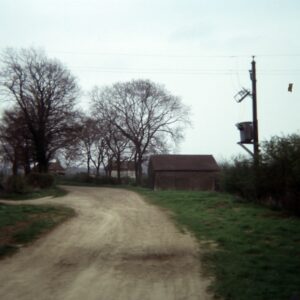 article together with those of the present day “characters” that undoubtedly exist.
WADES CLOSE TO WESTERN END OF ORCHARD LANE
The only properties on the south side of the lane shown on the 1901 map are a cottage and barn. These two buildings which are opposite the village hall; the cottage still occupied and the barn replaced by a house. The only other property (Yew Tree Cottage) at this time was at the western end on the north side.
A bungalow was built to the west of Yew Tree Cottage, with a plot of land between which eventually had another bungalow built there.
In the 1985 a plot was sold at the end of the White Swan garden for the construction of a house.
At 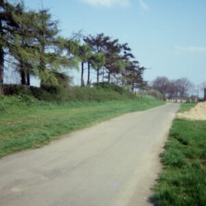 the same time, on the south side, two modern style houses were commenced on plots of land purchased by two families who were moving into the area. The one house was a copy of a house built on Canvey Island by one of the families. The other, which at the time, was quite unique for Woodnewton in that it had a flat roof; the owner being from a Greek Cypriot family named it Kalifi. A later owner converted it to a ridge roof.
The development of Orchard Lane was completed with the construction of two houses in what had been the garden of Yew Tree Cottage.
2016